
NEXT ARTICLE
Greenwashing, the practice of making misleading environmental claims, has become a growing focus of litigation as consumers and regulators demand that companies substantiate their sustainability promises. These cases can arise from false carbon offset claims, misleading representations about the use of recyclable materials, or other deceptive statements related to environmental practices.
In 2025, two high-profile carbon offset class actions, Dib et al. v. Apple Inc. and Bell v. R.J. Reynolds Vapor Co., both advanced past motions to dismiss, a rare outcome in this area of law, positioning them for potential settlements worth hundreds of millions of dollars.
Now, an even newer subset of greenwashing litigation is targeting supply chain greenwashing, in which companies assert that their products are sourced responsibly, such as promoting “deforestation-free” palm oil or “ethically grown” crops, when the reality is far less certain. If those claims prove false in court, the companies making those claims can be found to be in violation of consumer protection laws.
Until recently, verifying the accuracy of global supply chain claims was a difficult and resource-intensive process. That is beginning to change. Artificial intelligence (AI) and remote sensing technologies are giving attorneys new tools to uncover the truth behind corporate sustainability statements. Remote sensing now makes it possible to see what is actually happening on the ground and provides compelling evidence in greenwashing investigations and litigation.

AI and Remote Sensing: A New Type of Evidence
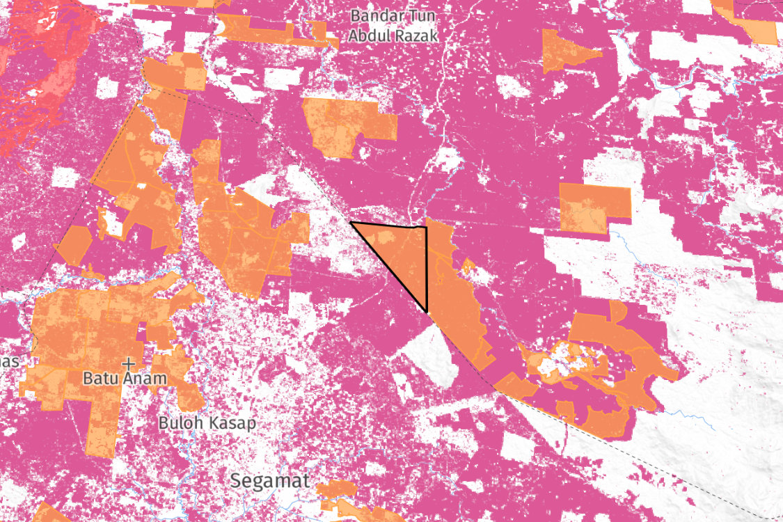
Remote sensing refers to satellite imagery and other aerial data that can monitor Earth’s surface. Modern AI advances, particularly machine learning, now allow us to analyze these images at scale, identifying land use patterns, crop types, and even instances of deforestation with remarkable detail. In mid-2025, Google and partners released AI-driven probability models mapping where key commodities are grown around the world.
These models provide per-pixel predictions (at 10-meter resolution) for the likelihood of a given crop (such as oil palm, cocoa, coffee, or rubber trees) being present. An attorney or investigator can use these AI maps to see what is being grown on every patch of land in a region.
These AI maps are paired with deforestation data. Earth observation programs like NASA/USGS Landsat and the European Sentinel satellites have, for years, provided open data on forest loss. Platforms like Global Forest Watch synthesize this into near real-time deforestation alerts. By combining these with AI-based crop classifiers, it’s now possible to trace agricultural expansion into forests. For instance, if a company claims its palm oil supply is “deforestation-free,” analysts can overlay the supplier’s plantation locations against satellite-based forest loss maps and AI commodity maps. If the AI detects oil palm cultivation in an area that satellites show was recently forest, that raises a red flag of potential greenwashing.
This technique was used by the Rainforest Action Network (RAN) in a 2024 investigation: satellite images revealed palm oil plantations illegally encroaching into a protected Indonesian rainforest, undermining corporate claims of sustainable sourcing. The ability of AI to pinpoint what is grown and where provides a missing link in supply chain verification; it’s no longer just if deforestation happened, but what crop replaced the forest, and who buys that crop.
Google’s Commodity Maps and Supply Chain Tracking
One breakthrough aiding litigators is Google’s new Agriculture Commodity AI Maps. Released under the Forest Data Partnership, these AI models estimate where commodities like palm oil, coffee, cocoa, and rubber are cultivated across the tropics. At 10-meter resolution, they can identify even relatively small plantations. The stated mission of this project is to “halt and reverse forest loss from commodity production by… improving global monitoring [and] supply chain tracking”. Ten countries (including Indonesia, Malaysia, Brazil, and Côte d’Ivoire) are covered so far for the palm oil model, aligning with major sourcing regions.
While these particular maps do not cover the US yet, in the future they will be incredibly helpful for tracking supply chains.
For example, suppose a snack food company advertises that its palm oil is 100% deforestation-free and sourced from sustainable plantations. Using Google’s palm oil map, one could identify the geographic footprint of oil palm cultivation in the supplier’s region. Then, using historical satellite imagery, one could spot any new plantation development in forested areas. If the data shows that significant oil palm planting occurred on recently deforested land, it directly contradicts the “deforestation-free” claim.
These techniques are equally applicable to other commodities. For example, cocoa labeled as “sustainably sourced” could be cross-checked against maps to see if it comes from regions known for recent illegal clearing.
AI is going to provide attorneys with an aerial witness to unbiased data that can call out false claims.
Remote Sensing in Action: Verifying Sustainability Claims
We are already seeing these tools deployed outside the courtroom in investigative reports and regulatory compliance. Environmental regulations are catching up to technology. The European Union’s Deforestation Regulation (EUDR), requires companies to ensure certain imports, such as cattle, palm oil, coffee, cocoa, rubber, soy, etc., are deforestation-free. To comply, companies must gather geographic coordinates of production and assess deforestation risk, a task practically impossible without satellite monitoring. According to a recent journal article published in nature.com, “Earth observation (EO) data are critical for transparent...compliance verification,” enabling “near-real-time monitoring of deforestation risks and commodity expansion across global supply chains.”
Non-profits have demonstrated the power of these methods, as well. The RAN case mentioned above prompted brands like Nestlé and Procter & Gamble to investigate and suspend rogue suppliers when confronted with satellite proof of illegal forest clearing, which just goes to show that the data is taken seriously.
What’s new is plaintiff attorneys are now bringing this evidence into litigation. High-resolution imagery and AI analysis can be attached to complaints or presented via expert witnesses, showing juries and judges clear visuals of environmental harm linked to a defendant’s supply chain. For example, an image from a satellite can show a before-and-after of a rainforest turned into plantations supplying a company that marketed “zero deforestation” as evidence in a false advertising case.
How Darrow Enables Evidence-Based Greenwashing Litigation
.png)
Greenwashing litigation is becoming increasingly evidence-driven, and plaintiff attorneys need technology that can reveal if corporations are making false greenwashing claims. AI, satellite analytics, and geospatial mapping now make it possible to identify patterns of deforestation, trace commodity origins, and verify or refute corporate sustainability claims. These tools turn what were once speculative allegations into data-backed legal arguments capable of withstanding strong defenses.
Darrow’s legal intelligence platform equips firms with this capability. Our legal intelligence analysts combine satellite-derived insights with advanced AI analysis, enabling attorneys to detect and substantiate environmental misrepresentations. Whether the issue involves false deforestation-free sourcing claims or deceptive carbon offset disclosures, Darrow provides the evidentiary foundation needed to pursue greenwashing litigation with confidence.
As regulators and consumers continue demanding transparency, reliable climate intelligence will become essential for successful environmental litigation.
This Might Interest You: